Sunday, April 22, 2012

Going Home

Today we got up early and went to the airport. We boarded our plane and took off promptly. As we flew towards the United States over the Atlantic, the man sitting next to me was nice enough to point out two geologic features. The first was the Cape Verde Island chains, which is the result of a hotspot. A hotspot pushes up little islands, and a plate moves over it, so it creates an island chain. The picture below will give you a better idea. The Cape Verde islands are located at 14 degrees north latitude and 24 degrees west longitude. The second feature we saw from our plane was a divergent boundary. A divergent boundary is where magma comes up between a plate, and dries. It then splits apart to let more magma up, so the two plates get further and further apart. A divergent boundary is the reason the Atlantic Ocean is widening. It is basically where the ocean splits. These areas are prone to earthquakes, because obviously, the movement of plate tectonics would create an earthquake. The earthquakes are pretty small though, and being underwater often makes them unnoticeable. Also below is a picture. Eventually we made it home. It was the smoothest day of the vacation and we are all exhausted.

Thursday, April 19, 2012

Day 4-7

We were rudely awoken last night by a magnitude 10.0 earthquake that sent me and my whole family flying through the air. We flew for about an hour, before we all smashed into a large piece of metal. It hurt badly, but when we oriented ourselves we discovered we had actually been shot into the side of the Eiffel tower, in France. We booked into a hotel and spent the next couple of days eating fancy cheese and being French. Soon though, it was time to head home.

Wednesday, April 18, 2012

Day 3

Upon landing in Kathmandu, we discovered that my son had a very serious leg condition that could only be treated by a nearby doctor in Pakistan. We were loaned a Volkswagon, and a person who knew the area drove us to the doctor in Pakistan. It was a long ride, and all of the bumps in the road made my son's leg hurt more. My wife and other two kids began to feel his pain. Eventually we reached the doctor, who was a very old man. He told my son to drink some potion, and magically, all of the bruising on my son's legs went away, and his leg felt better. The man was also nice enough to tell me that where we were was called a transform boundary, which occurs when two plates slide in opposite directions against each other. In our case, we were on the border of the Arabian and Indo-Australian plates, at 29 degrees north and 69 degrees east. These areas are prone to earthquakes. The San Andreas Fault is an example of this, which is why San Fransisco and Los Angeles have so many earthquakes.I hope that we eventually make it to Paris.


Thursday, April 5, 2012

Day 2

We spent the night at the airport in Seattle, and boarded our flight bound for Japan. Most of the flight was spent sleeping, and by the time we touched down in Japan to refuel we were well rested. The flight attendant told us that Japan was another example of a subduction zone, as the pacific plate crashed against the Eurasian plate. Soon enough, we were back up in the air. Unfortunately, my son, when he went to the bathroom, accidentally hit his head on the ceiling of the lavatory. His head hit the smoke detector, and authorities quickly closed in, as disabling a smoke detector is a federal offense. The air marshal tackled my son, shattering many bones in his leg. The plane had to make an emergency stop in Kathmandu, Nepal. Lucky for us, a doctor was on board the plane. He was able to stabilize my son’s leg. As we were landing, we noticed that the Himalayas were just out of the window of our plane. I asked how they were created, and a flight attendant told me that the Himalayas were an example of a collision boundary, which occurs when two plates of the same density collide, forming a tall non volcanic mountain. These areas are also prone to earthquakes, as the plates keep ramming each other. The Himalayas used to be a subduction zone but currently it is a collision boundary, with India smashing into it causing the mountains. Mt. Everest is the tallest mountain in the world. It sits at Latitude 28 N and Longitude 86 E.Below is a picture of a smoke detector on an airplane, Mt. Everest, and a diagram of a collision boundary.


Wednesday, April 4, 2012

First Day

We left the airport early this morning. We arrived at the airport, and printed out our airline tickets. Coping with the new touch screens at the kiosk was tough, and we had to rush to get through Security to reach our flight. Evidently at Security you must remove all belts, shoes, and watches, or they will remove them for you. My wife found it extremely creepy that these old men took so much interest in patting her down.

The flight went relatively smoothly, and we landed in Seattle 15 minutes earlier than scheduled. Unfortunately, though, when we were retrieving our bags from baggage claim, a misplaced Grizzly Bear approached my precious two children. Fearing for their lives, the children ran. They ran for miles, until they found themselves trapped in the crater of a nearby mountain named Mt. St. Helens. Luckily though, a park ranger was on hand to witness this horrific account and he shot the bear, ending the horrific ordeal. On the way back, the park ranger showed us how Mt. St. Helens was an example of a subduction zone. As we learned, the Atlantic Ocean is widening due to a divergent boundary, and it is pushing the North American plate against the plate of Juan De Fuca. These two plates collide, and because one of them is more dense (heavier, sinks), it gets pushed under (subducts) into the mantle. It becomes lava, and gets shot out as a volcano. Before an eruption, there are many earthquakes. Scientists use these earthquakes to predict when an eruption will happen. Most recently, there was a major eruption in 1980, killing more than 50 people. Mt. St Helens sits at latitude 46 degrees N and 122 degrees W.

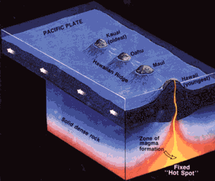
Below is a picture of me and my family before we drove to the airport, the crater that my son was rescued in, and a diagram of a subduction zone.


Intro

Hi all. I created this blog to share the remarkable journey that me and my family will take from Chicago, Illinois. We will travel around the world, hopefully ending up in London, England. To reach the magnificent continent of Europe, we will begin the first leg of our journey by flying out towards Seattle, Washington. From there we will fly west to London, making one stop in Japan to fuel up. Hopefully we will reach Europe, where we will vacation for a full week.